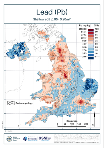
BGS (British Geological Survey) scientists have discovered significantly elevated concentrations of several elements in the soil within many urban areas of the UK. The findings are based on the most extensive snapshot of the UK’s topsoil chemical data ever produced, which has now been made available to the public for free as part of a world-leading BGS project.
Over four decades, several hundred scientists collected around 58,000 topsoil samples from rural and urban areas across the country to create the most in-depth and exhaustive map of its kind available globally. The data revealed that several elements, including antimony, arsenic, cadmium, calcium, copper, lead, tin and zinc, are present in soils of many of the UK’s urban areas as a result of environmental pollution.
This is the first time that such a large-scale dataset has been used to evaluate environmental pollution in the UK. It provides a vital reference point for establishing the distribution of several potentially harmful elements (PHEs) in the urban environment. It will enhance the understanding of interactions between people and ecosystems and help to focus further research into the effects the soil chemical environment may have on human and ecosystem health.
Paul Everett, geochemical survey expert at BGS, said: “This mapping project represents one of the most detailed datasets of its kind anywhere in the world. This data is useful for a multitude of purposes and will help to pave the way for enhanced decision making around the planning and development of the communities in which we live.
“Through a greater understanding of the mix of geochemical elements, the UK can enhance its strategic land use planning. This will have a significant effect on decision making around land use, environmental hazards, food production, soil health assessments, identifying new opportunities for mineral exploration and continuing to identify and quantify human impacts on the environment.”
The ability to pinpoint the distribution of 41 different chemical elements and identify areas where human activities have affected soil geochemistry gives us invaluable insights and forms a key baseline for researchers from a wide range of disciplines.
The data is available for all to view and download for free on the UK Soil Observatory (UKSO) web portal and will likely prove an essential resource for scientists, developers, local authorities and environmentalists for centuries to come.
About the project
The dataset is provided and to be used at national (1:2 500 000) to regional (1:1 000 000) scales; in the surveyed 25 urban centres, the dataset can be used at larger scales up to the resolution of the 500 × 500 m prediction grid cell; that is, a nominal scale of 1:500 000 with a zoom in up to 1:250 000 scale only.
The UK Compiled Topsoil dataset will provide a resource for research into the effects the soil chemical environment may have on people’s health, though this is a specialist area for health professionals and researchers that is not directly within the remit of the BGS. For answers to health-related questions, please contact your local authority or your local Health Protection Agency’s health protection unit.


 will be CRH's next chief executive officer, succeeding Albert Manifold (left) who retires at the end of this year. Image: CRH")

 EVO impresses with a feed capacity of up to 350 t/h in natural stone and recycling")