on rock for a 2475-year return period. BGS © UKRI. Contains OS data © Crown copyright and database right 2024")
The updated modelling from British Geological Survey (BGS) comes at a time when the UK is seeking to bolster its offshore renewable energy infrastructure and meet its net zero commitments.
Dr Ilaria Mosca, earthquake hazard researcher, BGS, said: “These maps are the first new UK offshore seismic hazard maps for more than 20 years. Methodological and computational advances mean that we are able to better understand which areas hold the potential to be heavily impacted by seismic activity and how to model the uncertainty (what is still unknown or uncertain).
“Offshore critical infrastructure, including windfarms and carbon capture and storage, are both essential for the transition to net zero, but it is also vital that we know what the hazard is so that high consequence structures can be designed appropriately to reduce risks to people and the environment.”
The UK experiences between 200 to 300 earthquakes annually, with the largest earthquake ever recorded being a 6.1 magnitude earthquake that occurred in 1931 in the Dogger Bank area of the North Sea, about 100 km from the east coast of England. More recently, in 2022, a 5.2 magnitude earthquake in the northern part of the North Sea shut down operations at an offshore oil platform without causing significant damage.
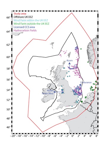
The North Sea and the Irish Sea have a strategic role in supporting the UK’s decarbonisation and net zero carbon ambitions due to the increasing number of licensed carbon capture and storage (CCS) sites located there. The presence of historic seismicity near these offshore CCS sites emphasises the importance of robust estimates of the potential earthquake hazard to underpin the planning and design of this critical offshore infrastructure.
The seismic hazard shown in the maps is computed using a model that consists of two parts: one that characterises earthquake occurrence (where they occur and their frequency of occurrence) and another that describes the ground shaking that may result from potential future earthquakes. The model is based on historical and instrumental observations of earthquakes and their effects, and information and data relating to the tectonics and geology of the region under investigation.
Dr Mosca added: “These maps empower developers with the knowledge of the areas that have the greatest potential for key infrastructure, including CCS, to be built without the serious risk of damage caused by the ground shaking produced by future potential earthquakes, helping to ensure net zero can be achieved alongside the safety of those on and offshore.”


 EVO impresses with a feed capacity of up to 350 t/h in natural stone and recycling")