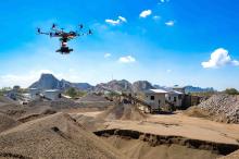
Drones and cloud-based platforms used to interpret the wealth of data they collect from flights over quarries are becoming increasingly used by materials processing professionals worldwide. Guy Woodford visited two quarries using this cutting-edge technology and reports on the latest developments in this sector.
As soon as the fixed-wing drone had landed at Groupe CB’s Limont-Fontaine limestone quarry, the UAV pilot transferred the images and GPS co-ordinated data to Redbird, the company which processes the aerial information.
Within 24 hours, Dylan Merkouloff, Groupe CB’s industrial performance manager, and Remi Fontaine, CB’s Quarries financial controller, can access 2D and 3D maps, as well as dedicated analytics on their sites, via Redbird’s secured solution.
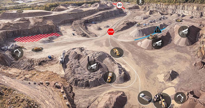
The maps and data extracted can simply and easily be compared to those gained from previous drone flights. Dedicated analytics such as stockpile volumes, haul roads, high walls and other site features are also retrievable from the cloud. “The web application is easy to use and intuitive,” says Fontaine.
Groupe CB has been exploiting minerals through industrial processing for over four generations. The company has been constantly searching for innovative solutions to revolutionise their sites and eradicate problems. Now, with drone data and the Redbird solution, they are digitising their site easily and efficiently, making their safety issues a thing of the past.
Fontaine finds that the Redbird solution gives him an accurate overview of stockpile management whilst ensuring time efficiency and increased productivity. “We fly drones regularly here. Every month, I use the Redbird solution for stock management work. It gives me up-to-date stockpile volume information which I can then use to work out the value of my limestone products,” says Fontaine. “It’s reliable and quick. Before, we used more onsite surveyors and it took two to three days to get information I can now get within 24 hours. Using drones and the Redbird solution enables me to deliver stock and other data to Groupe CB management more quickly.”
Indeed, on-site safety regulations are key. According to Fontaine: “Using drones is also safer than having an on-site surveyor analysing stockpiles.” French quarry site legislation stipulates that each haul road berm is at least 50% higher than the biggest wheel on any passing equipment model. “The Redbird solution data helps us meet this requirement,” explains Merkouloff. “It also enables us to be within legal haul road slope grades and to monitor the height of high walls.”
Merkouloff explains other benefits of the Redbird solution for all Groupe CB’s sites. “One of Groupe CB’s surveyors is using the data accessible through the Redbird solution, such as haul road analytics to optimise quarry design. These changes will translate into higher fleet usage and reduced fuel consumption while feeding the crusher at the targeted production.”
This not only helps reduce fuel consumption and increase productivity, but also aids planning. The Redbird solution allows for the sharing of and collaborative working with quarry group data, which may include individual key project/account progress, and images or documents from one or more sites within the Group’s portfolio. This can be shared among as many colleagues as management wishes, keeping everyone up to date with operations and allowing for precise planning.
Each year, CB’s quarry management gives a presentation to the local community about its working practices. “Through the Redbird solution, we can present 2D and 3D images and information about noise pollution, dust levels and other things,” says Merkouloff.
Of Redbird’s work with Groupe CB, Benjamin Hugonet, the former VP of Sales and Co-founder of Redbird, and current VP of European Sales at Airware, says: “Groupe CB’s quarry was our first Redbird contract. They took out our best package in June 2015, and we signed another contract with them in June 2016. This first contract has helped us to sign other customers. Groupe CB is a big independent and very strong company in France. I’m pleased that they are more than happy with all the data we can provide them.”
Groupe CB is expecting a number of its employees to gain their drone pilot licences before the end of 2016, removing the cost of utilising external pilots.
Redbird was recently acquired by Airware, a San Francisco-based company providing complete commercial drone solutions. The merging of Airware’s powerful enterprise-focused workflow, compliance, and security features and Redbird’s innovative analytics application produces an end-to-end solution for the heavy industries, from the drone flight to the powerful analytics cloud solution.
Established in 2013, Redbird was among the leading start-ups in the analysis of spatial data collected by unmanned aerial vehicles (UAVs). The company’s global marketing agreement with
Indeed, it was the conversations between a representative of Bergerat Monnoyeur, the French Caterpillar dealer, and innovation-seeking Groupe CB senior management that led to drones and the Redbird solution being deployed at Groupe CB quarries.
As Emmanuel de Maistre, the former CEO and co-founder of Redbird and current VP of Operations for the AEC department at Airware noted, after the Caterpillar-Redbird Marketing Agreement was finalised in December 2015: “Our solutions have been developed with leading construction companies and quarry operators for the past two years, helping them extract the real value out of drone data. We are honoured by this collaboration with Caterpillar, which will bring tangible benefits to construction sites, mines and quarries, helping customers work faster and safer.”
Now with Airware, the Redbird solution will be offered to mines and quarries globally.
As part of a trial of the potential use of drones to support its operations,
“Currently, we have an independent stock survey carried out on a monthly basis,” explains James Veakins, manager of the Chipping Sodbury site. “Using this information for the stock on the ground relative to the sales for the month over the weighbridge gives me an idea of how much material we need to process in the coming period.
“The problem with this is that we only get our exact on-the-floor stock measurement on a month-by-month basis. Some of our products are fast moving. For example, I could be selling 2,000 tonnes a day of our Type 1 aggregate when we’re extremely busy. It’s very difficult for our sales team to be confident when speaking to customers that there’s enough stock available at this site to satisfy the orders they’re taking.
“My foreman and supervisor are assessing stockpile levels every day, but it’s a visual best guess, albeit an educated one. This Kespry technology allows me on a weekly or even daily basis to get very accurate stockpile measurements of all the different sized aggregate products I have available. I can then use that information to determine how I set up my crushing and screening plant to optimise the production of different materials. For example, if I’m selling an awful lot of 10mm premium product, I can adjust the settings on the processing plant to make more of it. I can also communicate the stockpile volume data to the sales team, so they’ve got a quick and accurate reference when communicating with customers.”
Veakins says that using information from Kespry’s drone and data analysis software also enables his quarry sales team to balance product orders, ensuring sound planning and delivery schedules.
The Kespry drone is, at heart, a quarry manager’s tool, with flights planned and launched using an iPad interface and avoiding the need for manual piloting. Flight areas are restricted to a pre-planned mission area and automatic pre-flight checks ensure that safety is maintained for both users and others near the mission area. Kespry says its new Drone 2.0 can fly for over 30 minutes at a time on a single battery, and with field-swappable batteries, can cover vast areas in a single mission, with its integrated computers and hi-resolution camera enabling it to gather terabytes of data and images. The drone’s on-board LiDAR system allows the drone to automatically avoid obstacles like birds, buildings, trees and cliffs. Post-flight data is automatically uploaded to the Kespry Cloud via the system’s on-board WiFi.
The Kespry Cloud is the aerial intelligence platform for the Kespry drone system, securely storing flight data and allowing access for stock measurements via a web-portal. Following data uploads, processing is completed within one to six hours, and 3D models are available to the user to create inventory reports using a comprehensive set of reporting tools available in the Kespry Cloud. Kespry says insights generated by the Kespry Cloud, which can be easily shared with colleagues, can contribute to the benefits and savings that come from progress monitoring and asset management.
“The Kespry Cloud web portal is very simple to use, and very intuitive,” continues Veakins. “There are four different types of image available from the data. An overall site image is always provided, set into a background image from Google Earth or similar, an overall contoured image – including the ability to overlay a ‘heat map’ showing relative height differences in colour bands, a 3D model image allowing me to navigate virtually around the surveyed area, and the option to view individual frames or images collected during the flight.
“The Kespry software has the drone taking camera shots every half a second during a flight. That’s an awful lot of images that are knitted together to give me one site overview. It also allows me to go into the system’s picture archive and look at lots of detailed high-resolution images from one particular area of the site.”
Veakins can see the advantages of extending Kespry drone and Kespry Cloud use at Chipping Sodbury quarry beyond the basic requirements for routine stock measurement. “Analysis of the geotechnical conditions of the site would be useful. I’ve got old quarry working faces two or three benches up that we no longer have safe access to. The drone can fly close to these faces and give me photographic imagery of their condition. This would enable me to see if there’s any rock movement over a period of time. In our active areas, I could also use the drone to create 3D models to make sure that the quarry’s haul road edge protection continues to meet regulations and highlighting those areas requiring remedial work to maintain safety.”
Hanson UK is part of the
“The primary focus of our interest has been in developing routine, low-cost solutions for stock measurement bringing this work in-house and providing the tools for quarry managers to collect data to support their work. The Kespry trial we have implemented in the UK, in Germany and the US has shown clearly that the system is one that is intuitive, easy to use and provides accurate and reliable data on which we make operational and sales decisions.
“Beyond stock measurement, we have been looking at other interesting applications that would either be expensive or inconvenient to implement routinely. Face condition monitoring is an obvious application, as is more frequent face position monitoring to ensure alignment with the quarry development plan. We see that one of the big potential uses of the Kespry system is for Building Condition surveys. We have some very tall and large buildings in many of our quarries, and we don’t really want to be sending people up on roofs,” says Wells. “High quality photographs of the roof will allow us to identify where there are holes, debris accumulating or birds nesting.”
Wells adds that he’s also been impressed by how supportive Kespry has been during the early use of its technology at Hanson UK sites in England and the U.S. and HeidelbergCement quarries in Germany. “We are in frequent contact with Kespry suggesting changes and additions to functionality of the Kespry Cloud. Kespry has responded positively to suggestions and has worked with us to enhance the user experience by making reporting easier and more adaptable to the needs of individual managers and sites.
“The relationship we have is mutually beneficial – we get the amendments we need to ensure that the tools are as easy to use as possible without the need for extensive training and understanding of 3D modelling, at the same time providing to Kespry real-world knowledge and expertise to support their wider development objectives.”
Wells concludes: “This is a tool that as a global aggregates business we see as definitely scalable and applicable in many countries and regions allowing us to harmonise and standardise on practices and process worldwide. This, in turn, directly supports our Group ambitions for consistent stock management and reporting, supporting both operational and financial planning.”
Both systems include an enhanced MAVinci Desktop Flight Planning software upgrade.
The first new package — Sirius UAS City Mapping Kit — includes a Fuji X-M1 8 mm lens designed to better capture urban surroundings. “It allows the image capture of vertical facades such as buildings, infrastructure and construction sites,” says Charles Rihner, vice president of the Topcon GeoPositioning Solutions Group.
“The upgraded flight planning software optimises the planning, preparation and processing to automatically produce a textured 3D model. Additionally, the kit allows the acquisition of 3D models and orthophotos when flying below 50 m altitude,” he says.
The second new package — the Sirius UAS High Resolution Mapping Kit — comes with a Fuji X-M1 27 mm lens. “This package allows the collection of images at the highest possible resolution for applications such as construction site monitoring, survey and mapping topography,” says Rihner. “It allows operators to obtain higher resolution images at the same altitude as compared with a standard lens.”
At INTERGEO 2016 on 11-13 October in Hamburg, Germany, Aibotix, the leading provider of UAV solutions, presented its latest innovations in UAV technology – while also celebrating the five-year anniversary of the Aibot X6 UAV.
Since 2011, many organisations worldwide are said to have relied on the accuracy and advanced technology of the Aibot X6 UAV and its accompanying software, Aibotix AiProFlight. Bringing claimed significant reductions in costs and time spent on projects all over the world, both software and UAVs are said by Aibotix to have been redefining workflows for aerial data capturing.
“The way surveyors and inspection professionals are working has changed significantly during the last five years,” says Lothar Assenmacher, Aibotix managing director. “The success of UAVs like the Aibot X6 is not only capturing aerial data but saving time and costs. We have been able to develop new features that complete the system, enabling us to offer everyone the opportunity to invest in the latest technology for aerial surveying and inspection.”
Aibotix recently introduced the redesign of Aibotix AiProFlight, as well as a broad range of fully integrated standard sensors. At INTERGEO 2016, Aibotix introduced the next step to make workflow even simpler with three new features to increase productivity and simplify aerial data capture missions.
Firstly, the new StoreIn Flight option enables users to store up to 1,500 waypoints on the UAV. This feature is said to allow users to upload very large missions and project data with just one click. The option allows the execution of missions automatically and independently from battery capacity, saving time and effort.
Secondly, with the new TeachIn Flight option, the UAV stores camera and recording position during manual flights, which are the crucial inspection parameters. In a second step, the user is said to be able to transfer the manual flight into a flight plan for an autonomous flight. This, says Aibotix, enables users to repeat missions with little planning at the same location at any time, saving time and significantly simplifying data acquisition.
Finally, 3D Visual, the new viewing module, gives pilots a means to visualise their flights in two separate windows - in on-top view and in a height profile. It offers a more detailed way of planning missions, particularly in rough terrain structures with varying heights or for inspection missions with complex structures.
“These new features in the Aibot X6 UAV and AiProFlight software provide for results-oriented and time-saving processing of large projects,” explains Tom Rudolph, director of Research & Development. “Professionals in areas like surveying, construction and monitoring will benefit from these latest developments. Standardised workflows and less processing time will be the visible results.”


