Of the $4.3 million to be awarded, $2.9 million comes from investments made by President Biden’s Bipartisan Infrastructure Law. Every dollar awarded by the USGS is matched by the state geological surveys, doubling the impact of the Federal investment.
Investments made through the Bipartisan Infrastructure Law have expanded the USGS National Geological and Geophysical Data Preservation Program’s capacity to support preservation of physical samples and earth science assets for future use, to advance new scientific discoveries, and to inform hazard mitigation, infrastructure development, critical minerals characterisation and climate resilience.
“The USGS and ultimately the Nation benefit immensely from USGS partnerships with the state geological surveys, such as efforts funded through the National Geological and Geophysical Data Preservation Program, the Earth Mapping Resources Initiative, and the Bipartisan Infrastructure Law,” said Geoff Plumlee, USGS Chief Scientist.
The United States is dependent on many critical mineral resources for purposes as varied as smartphones, fertiliser, defense applications and renewable energy. As increased attention is placed on the vulnerabilities of supply chains for these mineral resources, there is more interest in domestic resource potential.
“The state surveys have a wealth of samples and geologic heritage that is critical to preserve, both for their historical significance and for their potential to aid in future research,” said Erin Campbell, president of the Association of American State Geologists. “The long-standing support from these USGS grants enables work that is important to both state and national stakeholders.”
The data and samples held by the state geological surveys are important for a variety of purposes, including identifying critical mineral potential, understanding groundwater resources and geologic hazards, and supporting infrastructure development. State geological surveys will contribute $4.5 million in matching funds to support these sample preservation projects.
The USGS National Geological and Geophysical Data Preservation Program has supported state geological surveys in preserving their data and samples since 2007 through annual grants. This year, in addition to the $643,000 in appropriated funding from the USGS National Geological and Geophysical Data Preservation Program and the $2.9 million invested from the Bipartisan Infrastructure Law, the grants were also augmented by $750,000 in appropriated funding from the USGS Earth Mapping Resources Initiative.
Funding will better preserve data by allowing scientists to preserve samples that can be used to identify critical minerals, improve storage conditions for physical samples, and invest in new technological approaches to characterise, use and understand those samples. It will also drive development of modern digital infrastructure that will improve public access to and delivery of the preserved data and materials.
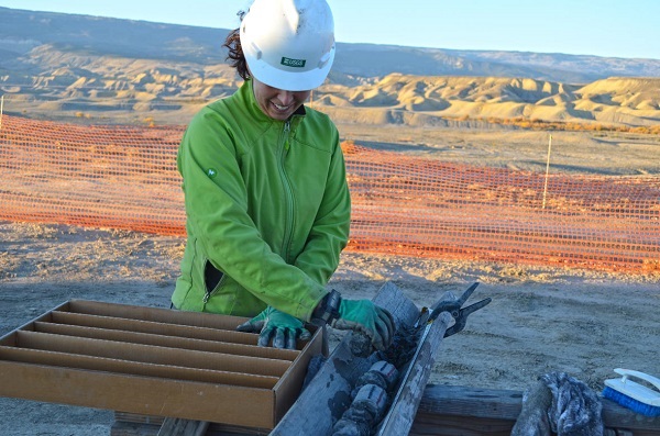
For example, manganese is a critical mineral essential to manufacturing steel, and Maine has significant potential for it. As exploration companies take interest in deposits in Maine, they approach Amber Whittaker, a senior geologist with the Maine Geological Survey, to look at rock cores taken from some of the deposits with the most potential., to look at rock cores taken from some of the deposits with the most potential.
“These cores are of great interest to these companies, but right now, we don’t have the best means to make the cores available for effective use. With funding we’re getting from the USGS through these grants, we hope to augment our core storage location so that companies, researchers, and the public can get the best use out of these assets,” said Whittaker. “In fact, it was previous funding from these grants that allowed us to save these cores in the first place, so the funding we’re getting this year is a natural outgrowth and shows the value of our continued partnership.”
Some minerals have implications for agriculture and infrastructure development. In Michigan, rock samples preserved at the Michigan Geological Survey, Michigan Geological Repository for Research and Education with USGS funding allowed companies to identify one of the richest potash deposits in the world in western Michigan. Potash is an important source of potassium for agricultural fertiliser.
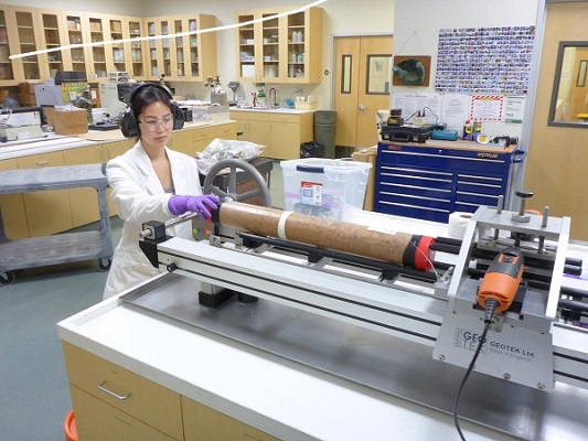
However, learning from the historical samples is just part of the story. Making sure those samples are well-preserved for future generations to get the same benefit is just as important. Many states have special repositories for these geological samples and data, and this funding helps them modernise, maintain, and expand as collections grow. As material needs, technologies, and our understanding of our resources grow and change, researchers will be able to reuse the samples preserved through this funding to provide the best available science.
More information about the National Geological and Geophysical Data Preservation Program and its grants can be found on the NGGDPP website.

.")


 EVO impresses with a feed capacity of up to 350 t/h in natural stone and recycling")