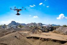
Oregon-based D&T Excavation (D&T) has selected Kespry's aerial intelligence platform to increase safety for inventory management and topographical analysis tasks. In addition, D&T will also use the drone's analytics and reporting capabilities to update its clients with progress on worksite projects.
Kespry's solution is designed with the intention of allowing operators to select the survey area and set the flight parameters on an iPad application.
Dan Liechty, project engineer, D&T, said: “Everyone's biggest nightmare is to bid a job and then find out that it's something different than what you're expecting. A lot of times, the existing contours or elevations we're getting from an engineer could be outdated or based on some inaccurate, not detailed survey techniques. There’s supposed to be all this dirt there and then it ends up not being there. With Kespry, we can go out there and verify it without spending two or three days doing a topographical analysis with a GPS base and rover.
“Using Kespry means more safety and saving time. It’s a huge pain to send somebody to the top of a rock stockpile and come down two or three hours later to end up with 15 topographical points, compared to the hundreds or thousands we get with the Kespry Drone", Liechty added.
George Mathew, CEO and chairman of Kespry, said: “Our earthworks-specific aerial intelligence tools are designed with companies like D&T in mind that require granular, accurate and on-demand inventory management. With Kespry, they’re able to gather the insight that drives successful and profitable earthworks projects without having to compromise the safety of their employees. We’re extremely pleased to help make the work lives of D&T’s employees easier, safer and more productive.”
